Model behaviour: Climate forecasting tools are getting better every day
What happens after we have that data?
Xander Wang used to be a kind of oracle of the ocean. For years, the University of Prince Edward Island professor got emails and calls from wealthy people in Ontario and Quebec, looking to acquire coastal property on the island. What they all wanted to know was how safe a prospective vacation home would be from rising sea levels. “They’d say, ‘Hey, Xander, I want to buy this property at this address. Can you tell me how many years I have?’”
In 2024, however, those emails and calls stopped coming. That year, Wang and the P.E.I. government released a free, interactive flood risk map known as the Climate Hazard and Risk Information System (CHRIS). Wang runs the Climate Smart Lab, which is part of the Canadian Centre for Climate Change and Adaptation at UPEI. CHRIS made it possible for anyone to see, in comprehensive detail, exactly how vulnerable every property was to coastal or inland flooding. The tool captures everything from water depth predictions to rates of erosion and, with the click of a mouse, how those numbers will change 50 or 100 years from now. (Spoiler alert: In a business-as-usual emissions scenario, they get much, much worse.)
As Wang points out, however, gathering good data is just the beginning. “When it comes to climate adaptation, you need action,” he says. To that end, his lab has also installed, in various provincial parks, 10-metre-tall monitoring towers that, through video and other sensors, collect data on erosion, ice coverage and storm patterns to help shape decisions about protection measures. Scale-model replicas of these measures — vegetation plantings, rock barriers, sea walls — are being simultaneously tested in the lab’s flood simulator. One of the only such devices in the country, this is essentially a Plexiglas water tank, five metres long and two metres wide, within which Wang has built a miniature east coast village and shoreline. Sprinklers and a wave machine simulate rainfall and tides respectively, with Wang’s team able to “plug in” the replica protection measures to see exactly how they fare against large waves.
The brutal impacts of a rapidly warming world have been on full, terrifying display this year — catastrophic heatwaves and wildfire across Europe and North America, deadly floods in Nepal and Tibet. With the world blowing past the temperature targets outlined in the Paris Agreement, it’s clear that mitigation is no longer a sufficient strategy. Adaptation, as Wang’s lab demonstrates, is only going to grow more urgent, with communities requiring short-term, immediate protections. While adaptation can be a hard sell — loss avoidance doesn’t generate cash flow — an economic case can be made. This year, the federal government released a report claiming that every dollar invested in adaptation generates $13 to $15 in economic benefits. The Canadian Climate Institute similarly argues that investing $4 billion a year in proactive adaptation would prevent most of the infrastructure damage caused by growing heat and heavier rainfall.
Like Wang’s lab, a number of Canadian companies are developing forecasting tools that can give us a much better understanding of flooding, wildfire and extreme heat, anticipating where and when new resilience measures will be most needed. That data is imperative, improving its quality necessary. But we can no longer build, work and live as if we still enjoy the relatively stable climate of the 20th century. We need to prepare for and adapt to a harsher, more chaotic world, and translating that data into meaningful, life-saving action is the only option we have.
Before the flood
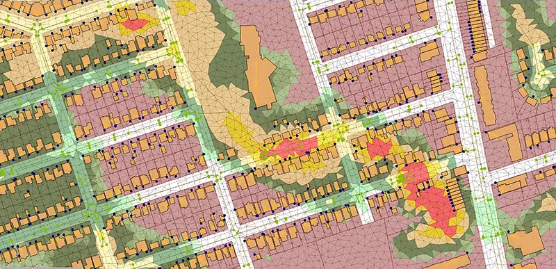
The CHRIS flood risk map, as detailled as it is, comes with a disclaimer: “These results are approximate and not suitable for site-specific property or infrastructure assessments.” Property and infrastructure assessments, however, are exactly what Toronto startup NOAH Intelligence does. Founded in 2024, NOAH is a flood risk modelling company that, using a physics-based model, has mapped the entire city of Toronto — 472,000 properties in total — to determine the vulnerability of each structure to rainfall. NOAH is currently in the process of applying the same approach to the entire country.
Like most North American cities, Toronto wasn’t built for the supercharged storm systems that now routinely drench the city. But adapting to this new meteorological reality is extremely costly and time-consuming. The city’s Basement Flooding Prevention Plan, which Toronto established in 2006, has ballooned to $18.6 billion and counting. Other interventions, such as new bypass tunnels to contain excess rainwater, are decades away from completion. “The city doesn’t have $18 billion dollars to fix the problem,” says NOAH’s co-founder and CEO, Chris Godsall. “And even if it did, it would take 30 years to fix it.”
What NOAH offers, then, is a way to better triage and direct that investment. More than 2,500 American municipalities and dozens of Canadian ones charge residents stormwater utility fees (aka “rain taxes”) to offset the cost of infrastructure upgrades. The City of Toronto, however, voted down such a fee in favour of doubling the support available to homeowners, subsidizing the cost of sump pumps and backwater valves. But according to Godsall, only 15 percent of property owners have taken advantage of those subsidies so far. With NOAH’s technology, however, more property owners can gain a keener understanding of their flood risk and, theoretically, act on it — the system also recommends concrete resilience measures that can reduce your specific risk. Municipalities, in turn, can then prioritize limited infrastructure budgets for areas at greater risk. Effectively, this buys municipalities time and more evenly distributes the adaptation load.
“It becomes a partnership between the citizen and the city in terms of resilience,” Godsall says. “There’s an enlightened self-interest.”
Line of fire
The circle of enlightened self-interest includes, critically, the insurance industry. Insurers are on the front lines of the climate crisis, grappling with the fiendish problem of having to underwrite properties increasingly under threat without putting themselves at financial risk. In 2024, for the first time, the insured damage caused by severe weather events in Canada exceeded $9.2 billion; between 2016 and 2025, there was $37 billion in insured losses from catastrophic weather and wildfires, nearly three times the amount recorded from 2006 to 2015. It’s nothing less than an existential threat to the industry.
With so much at stake, insurance companies have a clear incentive to invest in, and push for, better, faster adaptation technologies. Following 2024’s so-called “Summer of Catastrophe,” the Insurance Board of Canada released a resilience plan calling for changes to how and where we build, new regulatory frameworks that encourage risk-based pricing and the development of more accurate, sophisticated hazard maps.
Mapping floods is challenging enough, but wildfire — the other main climate peril Canada now routinely experiences — is even more difficult. Until recently, most decision-makers have relied on static, coarse maps that haven’t kept pace with the increasing speed and spread of wildfire. In 2025, however, Property Guardian, a U.S. company that provides wildfire intelligence to the American insurance industry, approached Apex Resource Management Solutions about developing similar solutions for Canadian customers. The Ottawa-based startup has spent decades perfecting its ecological modelling platform, which is used by dozens of government agencies and NGOs to track everything from wildlife populations to carbon dynamics. Adding wildfire modelling to the platform was achievable, and, according to ApexRMS president Colin Daniel, made possible because of the recent availability of affordable, high-performance computing. “Only in the last two years has it been practical to generate a hazard map of the entire country,” he says.
Feeding data from the Canadian Forest Service and other government agencies into its platform, ApexRMS is able to create annually updated wildfire hazard maps at fine, 30-metre resolution, which can simulate tens of millions of fires. Just like NOAH and flooding, ApexRMS’s software can also run “what if” scenarios to determine how adaptation strategies — removing vegetation from outside a home, say, or adding a golf course as a firebreak to a housing development — will reduce risk.
Over the last few months, since releasing the product, ApexRMS has been on a listening tour, meeting with insurance companies, utilities and, most recently, municipalities. The demand for better wildfire data, Daniel says, is there. But the data still needs to be leveraged for actual, ground-level protection. “It’s billions of dollars to do fuel treatments on any kind of scale to protect a town or city of any size,” Daniel says. “Where’s that funding going to come from?”
What could significantly change things, as everyone from insurers to the Canadian Climate Institute have argued, is an overhaul of how we bankroll climate adaptation infrastructure. “We need to find ways to get additional sources of capital flow and investment into these things,” says Brendan Seale, assistant vice president and head of sustainability at Definity. (Full disclosure: Definity is a sponsor of MaRS’s Adaptech Accelerator.) Currently, Canadian municipalities maintain 60 percent of roads, bridges and waste systems but receive only 8 percent of tax revenue. Seale would like to see this imbalance addressed through more strategic, innovative use of private capital: “We have to figure out a way to get the pension funds, the insurance companies and the banks bringing money to the table where they can get some return back for investments in infrastructure that make us more resilient.”
Line of defense
At the moment, P.E.I. is the only province or territory that has free, public access to comprehensive flood risk data. And it was possible to do, Wang acknowledges, because the province is small and relatively tight-knit, with a government that has invested significantly in resilience. (The Government of Canada has developed an open-source flood data map for the whole country, but other provinces have been slow to adopt it out of concerns such information will negatively impact housing markets.) Wang is trying to go even further, however, and is working on a real-time flood risk tool, which would give users up-to-the-minute data about localized flooding; he hopes to have that available in two or three years.
There isn’t a national standard for protection measures, however. Those are far more costly and complex, with different provinces and municipalities facing unique challenges — preventing overland flooding in Toronto or Winnipeg is different than it is in Charlottetown. But without them, the data that we so carefully collect, the maps we so carefully construct, are meaningless.
“With the emissions that we’ve pumped into the atmosphere worldwide over the last 40 years, there’s a certain amount of climate destabilization that’s just baked into the system,” says Definity’s Seale. “We have to respond to that. And it’s going to be economically damaging to delay and defer those kinds of investments.”
Explore more adaptation solutions at MaRS Climate Impact, November 17 and 18. Check out the program here.
Photo illustration: Made by Emblem
-
 Jason McBride